Reference: Ir-Ex-9575

Brand: Iridium

Iridium Extreme 9575 satellite phone

The hardest Iridium Satellite Phone for the whole World Easy to Use, Robust and Weatherproof With the Iridium Extreme 9575 you hold one of the most robust satellite phones in your hands with which you are reliably connected all over the world on land, at sea, on the mountain, in the valley, in the Arctic and Antarctica. Use voice, text and mail for your...

Price €1,599.00
Last items in stock

Reference: THSimPrPN

Brand: Thuraya

Thuraya Prepaid SIMs for Thuraya phones

The Thuraya Pre Paid SIM Card for all Thuraya Phones This Thuraya SIM Card fits all Thuraya Satellite Phones (XT, XT light, XT PRO, SatSleeve, SatSleeve+, Hotspot, X5). The SIM Card is a MINI/MICRO/NANO SIM and therefore fits all Thuraya Satellite Phones. The Pre Paid SIM card is available as Thuraya NOVA SIM and as Thuraya Standard SIM. The NOVA SIM card...

From Price €99.00
In stock

Reference: IR-PrP-SIM-Voice

Brand: Iridium

Iridium Prepaid SIM

The Iridium Pre Paid SIM card for all Iridium Satellite Phones This Iridium Pre Paid SIM card fits all Iridium Satellite Phones (Extreme 9575, Iridium 9555, Iridium GO!). The SIM card is a MINI SIM. Iridium Pre Paid SIM cards can be charged with different credit packages with different validity periods. The smallest package is 70min for 30days. Unused...

From Price €12.00
In stock

Reference: IRI-PrP-GUT

Brand: Iridium

Iridium Prepay Credits

Iridium prepaid SIM card activated for all Iridium phones This credit can be used only for SIM cards activated by us.When ordering, please enter your Iridium phone number and SIM card number in the additional fields.If you urgently need new credit and have no access to our webshop, please contact us 24/7 at our hotline number 0043 660 711 7777 via SMS or...

From Price €219.00
In stock
All best sellers
Garmin 66i, help, distress, navigation, weatherproof, emergency, ship data, marine, satellite communication
  • Garmin 66i, help, distress, navigation, weatherproof, emergency, ship data, marine, satellite communication
  • Get detailed maps without a subscription. The 16 GB internal memory offers enough space.
  • navigation, emergency, gps, garmin, worldwide, global, connection, safety, satellite, satellite link, tracking, robust, distress

GPSMAP® 66i Garmin InReach Land Navigation

66i Garmin

More Adventure, more safety with the Garmin inReach GPSMAP 66i

Compact, robust and accessible worldwide

The Garmin GPSMAP 66i is a rugged GPS outdoor handheld for perfect navigation and worldwide accessibility thanks to inReach technology via the global Iridium satellite network. You can plan, view and synchronize waypoints, routes and tracks.

You can easily get your current position and share it with your loved ones back home. So they always know where you are and that you are fine.

You get detailed maps without any subscription at all. The internal 16GB memory offers enough space. Readable in any light, usable in all conditions - that's what the Garmin inReach GPSMAP 66i was made for.

€599.00
Tax included 7 days
Quantity
expected soon

Last time this product was added to a cart: 06/07/2022

Description

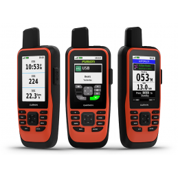
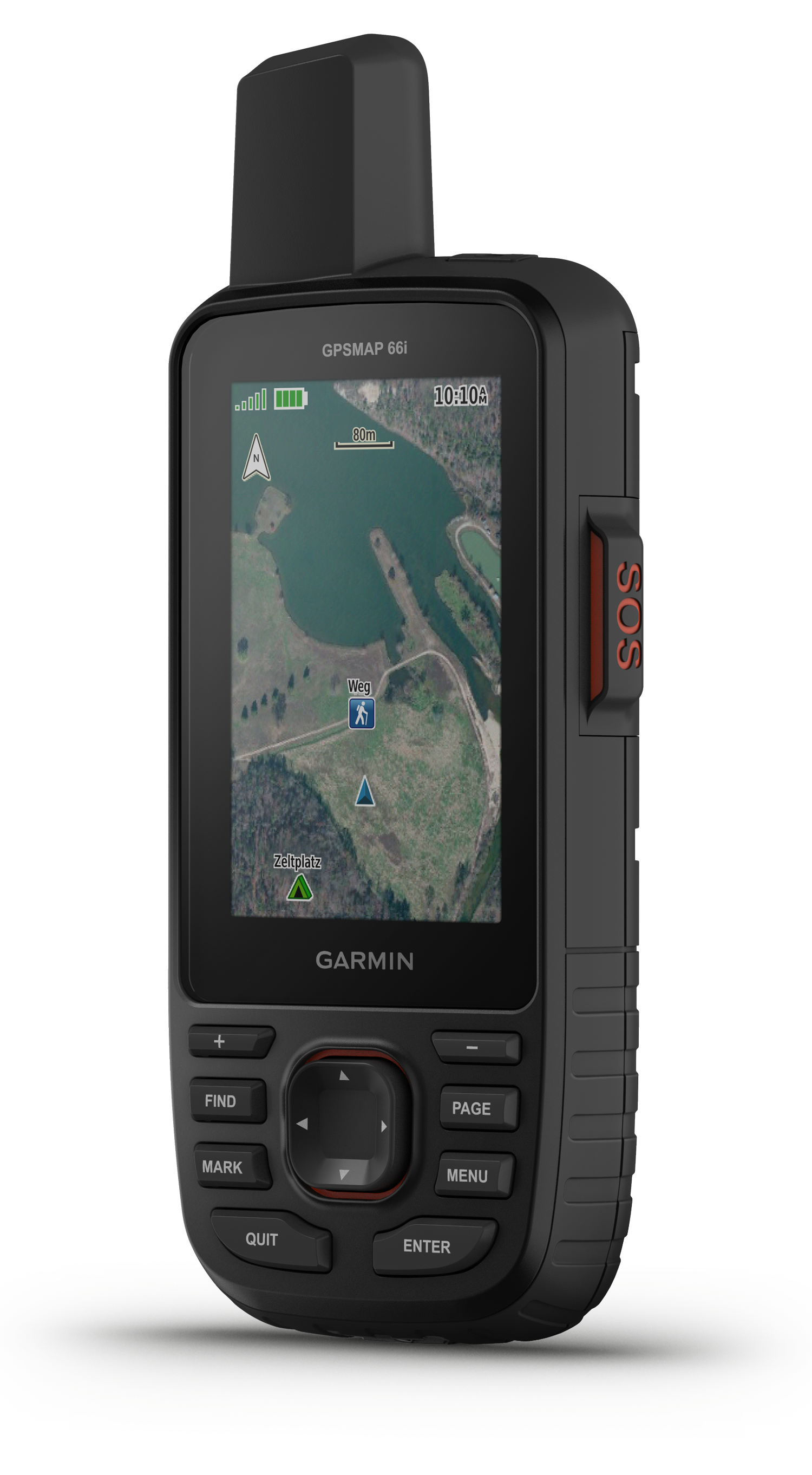
The rugged GPS outdoor handheld for perfect navigation and worldwide accessibility


Preloaded Europe Maps

See peaks, parks, coastlines, rivers, lakes and geographic points on the preloaded TopoActive Europe maps. Your adventure can start immediately.

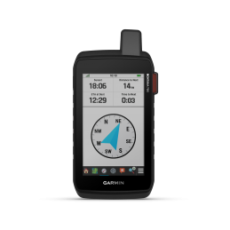
Optimal orientation with ABC sensors

Navigate all trails with ABC sensors, including an altimeter for elevation data, a barometer for monitoring the weather and an electronic 3-axis compass. So you'll always find your destination.

BirdsEye Satellite Images

Download high-resolution, photo-realistic maps directly to the device without an annual subscription. Then discover trails, select high seat locations, find parking, create waypoints and more.

Multiple satellite systems

Use multiple global navigation satellite systems (GPS and GLOSNASS) to get better position finding in more challenging environments than using GPS alone.

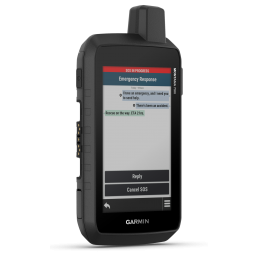
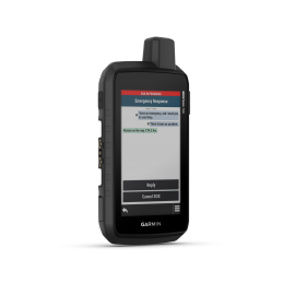
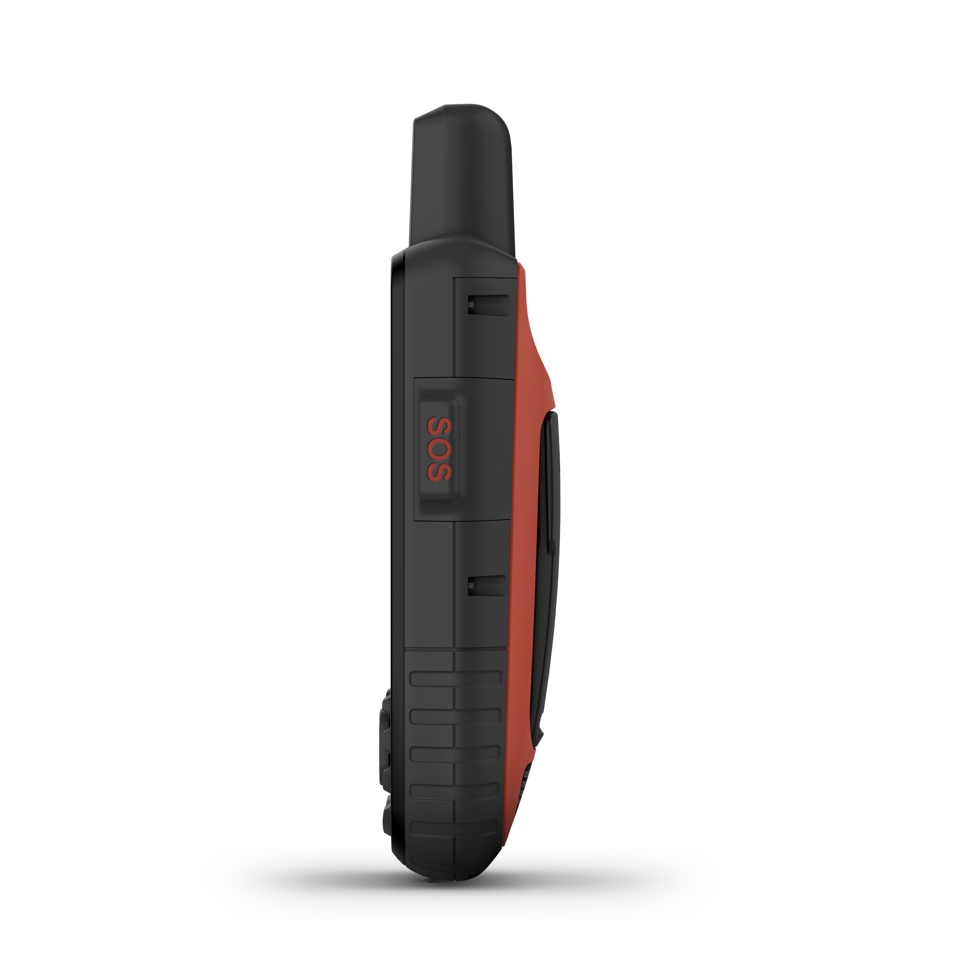
Help in an emergency anytime and anywhere

In an emergency, trigger an interactive SOS emergency call to GEOS, the Garmin-powered International Emergency Response Coordination Center (IERCC) and a professional, 24/7 global monitoring and rescue center (satellite subscription required).

GEOS Alliance

GEOS is among the leading providers of emergency response solutions and monitoring. The company has helped save many lives in rescue operations in over 140 countries. The center is staffed 24/7 throughout the year to respond to your SOS emergency call, locate your device and notify the appropriate contacts and emergency services in your area. Once you place an emergency call, you'll receive confirmation that help is on the way and continuous updates on the status of the rescue mission.

Share your current location

You can easily get your current location and share it with your loved ones back home. That way, they'll always know where you are and that you're okay. Satellite subscription required.

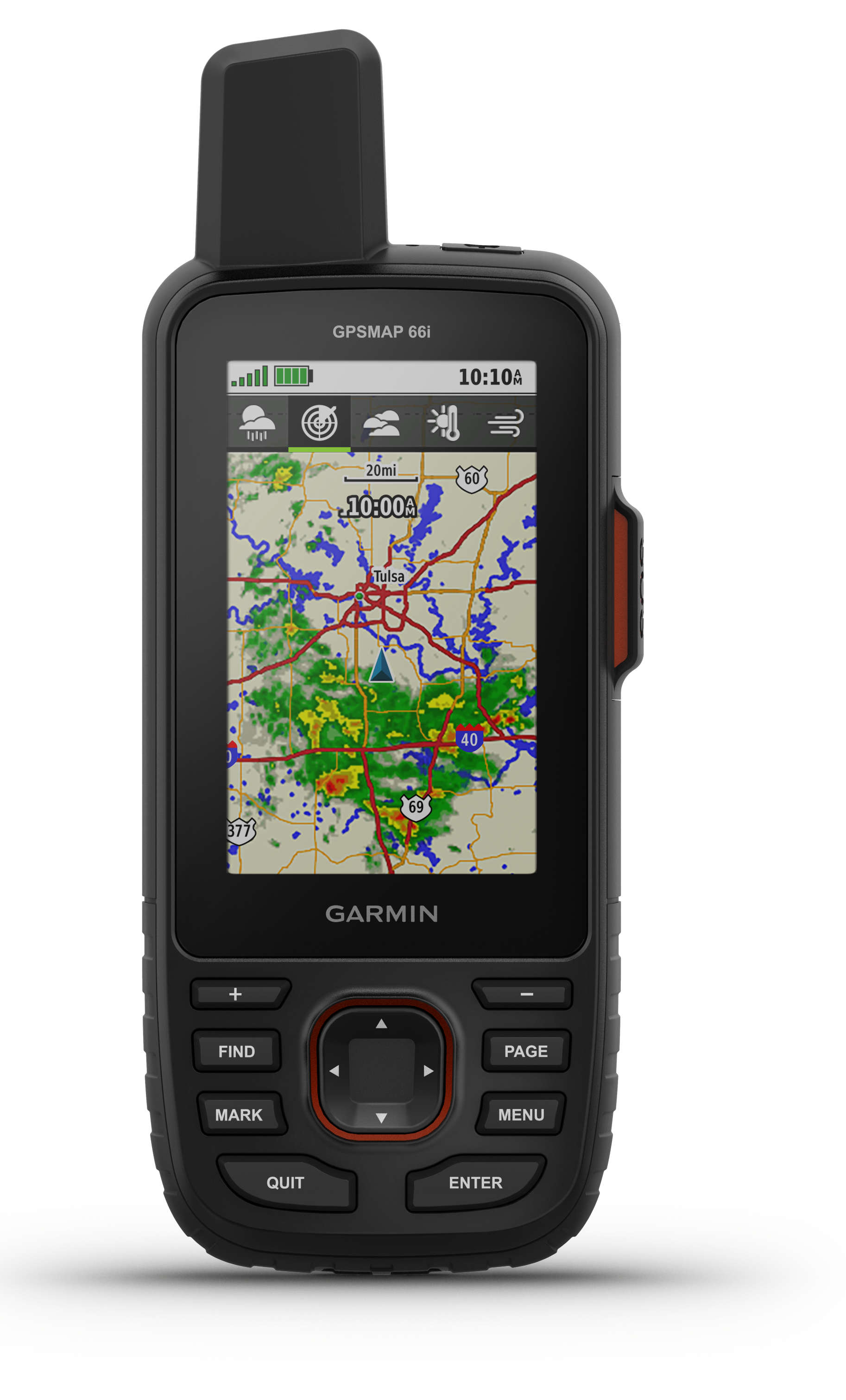
Weather data, even from your smartphone

Get detailed weather updates on GPSMAP 66i or a device paired with the Garmin Explore app. Request forecasts for your current location or for other waypoints or destinations on your route. Pair GPSMAP 66i with a compatible smartphone and get real-time forecast information and live weather radar data. So you are always and everywhere well informed.

Expedition mode, battery

In Expedition Mode, you can be on the road for over a week without having to recharge in between. In LiveTrack mode with 10-minute tracking interval, the runtime is still up to 35 hours, so a weekend.

LED flashlight for the dark

The GPSMAP 66 series helps you keep your gear to a minimum. One example of this is the integrated LED flashlight, which can also be used as an auxiliary signal.

Compact and extremely rugged

This handheld unit is extremely rugged, shockproof (MIL-STD-810F) and waterproof. In addition, it is also compatible with night vision goggles. You are guaranteed to be well equipped for any adventure.

Product Details
66i Garmin

scope of delivery

  • GPSMAP 66i
  • Access to BirdsEye satellite images
  • USB charge/sync cable
  • Carabiner clip

technical specification

Dimension and Weight

  • 6,6 x 16,3 x 3,5cm
  • 241g

Display

  • 3,8 x 6,3cm; 7,6cm (3Zoll)
  • 240 x 400 Pixel
  • Transfletive TFT color display

Battery

  • up tp 35 hours with 10minute tracking
  • up to 200 hours with 30minute tracking (power saving mode)
  • Lith-Ion

Interface

  • high speed micro USB
  • NMEA  0183 compatible

Wireless connectivity

  • Wi-Fi
  • Bluetooth

Memory and power capacity

  • microSD card (not included)
  • 16GB storage

Others

  • Waterproof IPX7
  • thermal performance, shock resistance, water resistance MIL STD 810

5 other products in the same category:

Reference: garmin750i

Brand: Garmin

Garmin Montana 750i handheld navigation/SOS

The Garmin 750i, built for all Adventures Versatile, robust and simple The Garmin 750i perfectly combines outdoor navigation and safety with global messaging and interactive SOS emergency call via inReach satellite technology with integrated 8 MP camera.Send and receive messages worldwide and place emergency calls 24/7 thanks to inReach technology.Track...

Price €809.00
Last items in stock

Reference: garmin700

Brand: Garmin

Garmin Montana 700 handheld navigation/SOS

With the Garmin Montana 700 you will always find your destination Reliable, robust and versatile The Garmin Montana 700 is a rugged, shockproof, heat and water resistant (IPX7) handheld device tested to US military standards (MIL-STD 810). It features a 5-inch transflective WVGA display that is glove-friendly and 50% larger than previous Montana...

Price €649.00
Last items in stock

Reference: garmin750i

Brand: Garmin

Garmin Montana 700i handheld navigation/SOS

Connected worldwide with the Garmin inReach 700i, thanks to inReach technology Robust, versatile and simple The Garmin Montana 700i combines outdoor navigation and the plus of safety in an outdoor navigator. Send and receive messages worldwide thanks to inReach and place emergency calls around the clock. Instead of relying on cellular coverage, your...

Price €709.00
Last items in stock

Reference: ISD2MARINE-DPB

Brand: Inmarsat

Anti-Piracy IsatDock2 MARINE Inmarsat Solution

The intelligent docking station for the Inmarsat IsatPhone Pro - specially designed for use at sea Safety first The anti-piracy solution ensures that communications can continue if all power or communications equipment on board a vessel has been cut off or destroyed by pirates.  The use of the IsatPhone 2's GPS system ensures that the dock can be located...

Price €4,790.00
on special order

Reference: 86i Garmin

Brand: Garmin

GPSMAP® 86i Garmin InReach Maritime Navigation

Always connected with the GPSMAP 86i Maritime handheld with inReach features Robust, simple and safe The GPSMAP 86i is a marine version of the popular GPSMAP 66i. Both combine GPS navigation with Garmin inReach technology. However, the GPSMAP 86i has a slightly larger housing than the GPSMAP 66i, making it floatable. In addition, the GPSMAP 86i can read...

Price €599.00
Last items in stock